Home | Session 2 | Earthquakes Have Their Faults
Earthquakes Have Their Faults
Presented
by Richard Sedlock
San Jose State University
Moving plates exert stress (force/area) on the rocks that make up the lithosphere. Several factors control whether on not this lithosphere breaks, producing an earthquake.
- Strength of rock. The strength of any solid material is the stress it can withstand without deforming or breaking. A rock is only as strong as its weakest part.
- Water within rock Pores and cracks in many rocks are filled with fluids like groundwater, which aids slippage. Fluid weakens a rock, so a rock with lots of fluid (especially fluid under pressure) breaks at lower stresses than a rock with less fluid. In the 1960s: Rocky Mountain Arsenal, Rangely Oil Field (Colorado)
- Temperature. A cold rock shatters or breaks; a warm rock bends or flows (Big Hunk candy bars). Temperature increases downwards in the earth. The transition from breaking to flowing (earthquake cut-off depth) is about 15-20 km in western California.
When rocks break to produce an earthquake, they move along a fault surface.
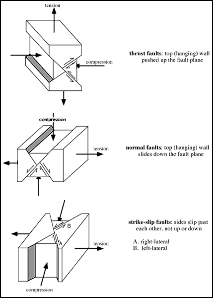
Geologists recognize three main types of faults: reverse (or thrust), normal, and strike-slip.
Your book (p. 45-47) attributes each fault type to a particular stress, as shown below:reverse/thrust fault
compressional stress
normal fault
tensional stress
strike-slip fault
shearing stress
However, geologists attribute each fault type to specific orientations of tensional stress and compressional stress (show in figure at left; click to zoom in).
Each type of faulting is characteristic of, but not limited to, one type of plate boundary. All three types are present in California, despite the dominance of right-lateral strike-slip faults.
We'll use scissors and a hand-out sheet (right, click to zoom in) to demonstrate why California (and specifically, the Bay Area) has normal and reverse/thrust faults.
Geologists can identify evidence that faulting, and thus earthquakes, have occurred in the past. Most common evidence: Abrupt termination of rock layers that originally were continuous.
What is the definition of active, anyway? In California: an active fault is one that has ruptured one or more times in last 11,000 years, or two or more times in the last 700,000 years. [CDMG maps of faults in the Bay Area - ordering information below.]
Some methods geologists use to identify faults (some don't always indicate active faults):
- Trenching and 14C ("carbon-14") dating are used to date layers & movements.
- Rocks along fault may be ground up (brecciated), polished, or striated.
- Ground-up rocks are easier to erode, so linear gullies or valleys may form.
- Fault scarps (escarpments), which will be eroded away if fault is no longer active.
- Offset surface features such as streams, roads, etc.
Whatever the means, a rupture starts at the focus or hypocenter (usually below the surface), then progresses outward within the fault plane.
The epicenter is the point on the surface vertically above the focus.
If we wanted to describe to someone else the exact location of an epicenter, what coordinates would we need to specify? How about for the focus?
_____________________________
CDMG Map Ordering Information:
San Francisco-San José quadrangle geologic and fault maps (order RGM005) $17 from
Department of Conservation, Division of Mines and Geology
P.O. Box 2980, Sacramento, CA 95812-2980
check or credit card; see http://www.consrv.ca.gov/dmg/pubs/index.htm
updated January 28, 2002
UCMP Home | What's new | About UCMP | History of Life | Collections | Subway
![]()