Home | Session 5 | Features of SF Bay Pg 1, 2, 3
Features of San Francisco Bay: From River Valley to Estuary
Presented
by Lise White
San Francisco State University
- San Francisco Bay Estuary
What processes have controlled the evolution of S.F. Bay?
A. Regional plate tectonics and geologic setting
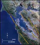
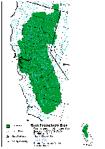
San Francisco Bay is a fault-bounded estuary, structurally controlled by the San Andreas transform fault to the west and to the east by the Hayward fault (figure 1, below left). The Bay can be subdivided into the South Bay, Central Bay (including the Golden Gate), San Pablo Bay in the north, and the Suisun Bay to the east (see figure 2 , below center).
Figure 1
Figure 2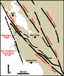
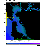
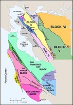
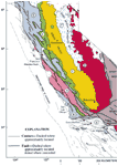
Figure 3Differences in rates of slip along segments of the right lateral San Andreas fault system that step to the right and left of the main trace of the fault (figure 3, above right), result in complex compressional and extensional forces that can result in structural highs (mountains) and lows (basins). The Bay Block is a topographically low region (figure 4, below left). The estuary's watershed (figure 5, below center)is large and it's river systems drain approximately 40% of the surface area of the state. Rivers and tributaries that start in the Sierra Nevada (figure 6, below right) join the Sacramento and San Joaquin rivers and eventually drain into the delta and San Francisco Bay.
Figure 4
Figure 5
Figure 6This drainage pattern has implications for the composition of the sediments that accumulate in the Bay and reflects erosion of igneous source rocks in the Sierra Nevada and sedimentary rocks of the Central Valley. These sediments deposit along the tidal marshes and mudflats of the Bay, and even and along the continental shelf where they are shaped by wave and coastal processes. During the hydraulic mining period that began around 1849 in the Sierra Nevada, mine tailings accumulated downstream resulting shoaling of the bay for decades after this.
updated April 1, 2002
UCMP Home | What's new | About UCMP | History of Life | Collections | Subway
![]()