Home | Session 1 | Plate Tectonics Page 1, 2, 3, 4, 5
Development of the plate tectonic theory
U.S. Navy: Bathymetry, sampling, and magnetic anomalies
In the late 1940s and 1950s, in order to track Soviet submarines and hide U.S. subs, the Navy funded echo sounding to study the bathymetry (underwater topography) of the ocean floors.
The stunning results revealed features very different from those on the continents. Generalized results were published as National Geographic maps, showing:
- submerged mountains, called oceanic ridges
- cracks perpendicular to the ridges,called fracture zones
- narrow, deep gashes, called trenches
- vast flat areas, called abyssal plains
- drowned undersea islands, called seamounts and oceanic plateaus
While these ships were cruising around the world's oceans, the scientists onboard requested and received permission to carry out additional "piggy-back" experiments.
- Using a dredging bucket, they periodically hauled up samples of the seafloor. They collected lots of mud, but also rocks such as basalt, gabbro, and serpentinite. No granite, no schist, no sandstone, no andesite....none of the rocks common on the continents.
- With a magnetometer towed behind the ship, they measured the magnetic field, and compared the results to values predicted from a model of Earth-as-dipole. Measured values usually differ from predicted values due to the effect of magnetic rocks.
Magnetic minerals align themselves with Earth's magnetic field when the rock forms (e.g., a lava flow cools), preserving a magnetic vector that can be measured with a magnetometer.
The difference between the predicted and measured values is a magnetic anomaly. Magnetic anomalies on land (widely available by the 1950s) exhibited irregular, splotchy patterns.
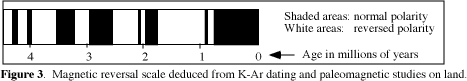
Magnetic studies on land showed that about half of the samples had "internal compass needles" that pointed south, instead of north. Geophysicists concluded that Earth's magnetic field has reversed its direction many times. Most geologists rolled their eyes at the idea.
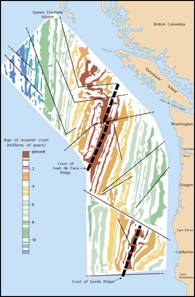
Ocean-going magnetometer studies helped clear up the mystery. Marine magnetic anomalies form linear bands of alternating positive and negative magnetism (see Fig. 2, above left, click to zoom in); i.e., rocks in half the bands (white on Fig. 3, below) are reversely magnetized—a N arrow on a compass would point south.
In the early 1960s, Bay Area geologists decided to test the hypothesis that the Earth's magnetic field reverses itself. They collected young volcanic rocks from all over the world, measured the magnetism of each, and determined the age of each (the latter with the recently-developed K-Ar radiometric dating technique).
The results:
- all normally magnetized rocks formed at certain times (Fig. 3: e.g., 0.0-0.7 mya)
- all reversely magnetized rocks formed at other times (e.g., 3.4-4.0 mya)
Scientists now conclude that the earth's magnetic field has reversed hundreds of times.
These findings were applied to marine magnetic anomalies:
- The linear anomalies on seafloor are symmetrical across oceanic ridges (Fig. 4, at right, click to zoom in).
- Pattern of bands correlates exactly with onland reversal sequence of Figure 3, above.
- Band over center is youngest, other bands are progressively older to the sides.

updated January 28, 2002
UCMP Home | What's new | About UCMP | History of Life | Collections | Subway
![]()