Online exhibits : Field notes : Diane Erwin
Diane Erwin: Paleobotany field trip to the Sierra Nevada
By UCMP museum scientist Diane Erwin, August 4, 2006
 |
|
|
|
In late July of 2006, the Botanical Society of America (BSA) held its annual meeting at California State
University, Chico. In conjunction with the meeting, UCMP cosponsored a paleobotanical field trip that ran
from August 3-6. This is an account of that trip.
|
|
|
|
|
|
|
|
|
|
|
|
|
Scientific field trips held in conjunction with the annual meetings of the Botanical Society of America (BSA) offer attendees an opportunity to visit and learn firsthand about the local plant life, as well as an area's history and culture. In late July, California State University, Chico hosted the Botany 2006 annual meeting, which celebrated the Society's 100-year history (pdf).
In conjunction with the Chico meeting, UCMP cosponsored the Paleobotanical Section
field trip. Museum Scientist Diane Erwin and Museum Associate Howard Schorn ran a three-day excursion to several Tertiary fossil plant localities throughout the western slope of the northern Sierra, with assistance from Jeffrey Myers, Anna Thompson, Stephanie Stuart, Lenny Kouwenberg, and Lanny Fisk. The trip's participants included 18 professional paleobotanists, botanists, and geologists.
Please note that this professional paleontological field trip and others associated with major scientific meetings visit sites on public lands that are administered by state and national government agencies such as the State and National Parks, National Forests, Bureau of Land Management, as well as those sites on private land. Collecting at such sites must be done with permission. In addition, many sites, like the ones on this trip, are under current scientific investigation and so any unauthorized collecting of these can have a serious negative impact on this research. Note that many of the specimens collected on scientific trips are not the private property of the collectors but are donated to museums or university paleontological collections where they are properly housed and cared for. The specimens are then available for use in research, developing public education programs, and teaching. The participants themselves are often associates of these institutions.
A lot of effort goes into planning a multi-day trip and so the leaders would like to acknowledge the gracious and generous support given us by the following people and institutions. It would have been impossible to conduct this field trip without you and the institutions you represent. Thank you!
Roy Caldwell (UCMP), Jeff Brown (University of California Sagehen Creek Research Station), Deborah Tibbetts (Archaeologist, Plumas National Forest, US Forest Service, Feather River Ranger District), Linnea Hanson and Chris Christofferson (Botanists, Plumas National Forest, US Forest Service, Feather River Ranger District), Terry Miller (Botanist, Tahoe National Forest, US Forest Service, Beckwourth Ranger District), Scott Lawson (Director, Plumas County Museum), James Belsher-Howe (Botanist, Mt. Hough Ranger District, Plumas National Forest), Virginia Moran (Botanist), Carl Schori, and the Royal Gorge Ski Association, Soda Springs, CA.
On the road to the La Porte locality
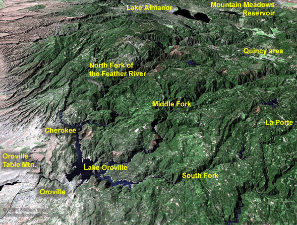
La Porte is south of Quincy, not far from the South Fork of the Feather River — to get there, we took the floristically scenic and geologically interesting Route 70 along the North Fork of the Feather River. A few miles north of Oroville, we passed by the historic town of Cherokee (see map, right) and the Cherokee Mine, an Eocene plant fossil locality. The Cherokee Pit locality is an old hydraulic gold mine where the plant-bearing sediments of the Ione Formation (Auriferous Gravels) are exposed, and although we did not stop here, the group would later see similar exposures at La Porte and the Buckeye Diggings (Day 3), learning more about the geology and deposition of these plant-rich shales.
Today, Cherokee is a near ghost town with only a few buildings still standing, like the one which houses the Cherokee Museum (photo 1). The Cherokee town site was originally founded by the Maidu Indians, but in the early 1850s, Welsh miners named it for a group of well-educated, emigrant Cherokee Indians from Oklahoma who had arrived in 1849 to pan for gold in the nearby streams. The presence of gold had been noted as early as 1818 by Spanish explorers. The Welsh miners moved in around 1853 and began working the Cherokee diggins using new advances in mining techniques. In its heyday (mid 1870s), Cherokee's population was over a thousand with three schools, three churches, eight hotels, and 17 saloons. In 1880, President Rutherford B. Hayes, Civil War General William T. Sherman, General John Bidwell, and other dignitaries visited the boomtown. Even though Cherokee has only about a dozen local residents today, they still hold the annual weekend celebration of President Hayes Day around September 24th, the day the President visited the town.
|
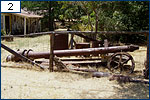 |
The Cherokee Mine was one of the largest (26,000 acres, 100 miles of sluice) and most famous placer gold mines in the world, with one of the most sophisticated hydraulic mining operations of its kind. A water cannon used in hydraulic mining is on display outside of the Cherokee Museum (photo 2). Earlier, it was mentioned that the Cherokee Mine is a plant fossil locality — UCMP houses two collections of Eocene plants from the mine and its vicinity. One small assemblage was given to UCMP in 1914 and came from about 200 feet below the surface, possibly from one of the mine shafts. During the 1930s, Professor Ralph Chaney and his students later collected additional leaves from several horizons in one of the stream canyons washed out by the mining operations.
Today, the mine is owned by the Idaho-based company Advanced Mineral Technology, Inc., and as recently as 1999, the company was proposing to reopen the area to mine the silica sand deposits leftover from the mining operations of the last century. Their proposal involved an open-type pit covering 120 acres. After processing and drying the sand, it was to be moved along a 4,000-foot-long, covered conveyor belt to the train tracks where it would be loaded onto trains or trucks. Needless to say, local environmental groups opposed the plan.
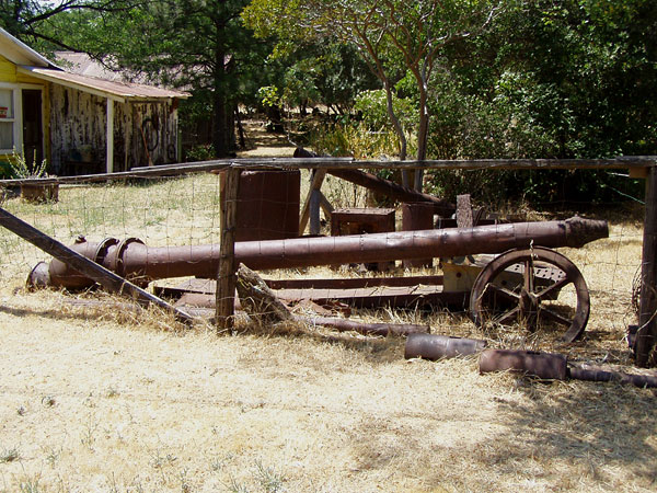
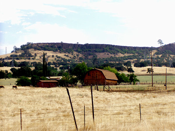
Cherokee sits atop the northern end of Oroville's Table Mountain, one of California's most notable geologic structures. The "Table" is a massive columnar basalt referred to as the Lovejoy Basalt (LJB). The LJB flowed into and filled what was then a "paleovalley" roughly 16 million years ago, but over time, the less resistant sediments of the valley walls eroded away, leaving the basalt high above its surroundings. So what appears to be the top of a hill today is actually the bottom of a former valley. The Basalt's age of 16 million years was determined using new isotopic dating techniques, revealing that it is much younger than the 50-million-year-old date attributed to it previously. Here is South Table Mountain (photo 3) as viewed from the exit ramp off Highway 99. Photo 4 shows the Lovejoy Basalt (dark columnar layer in the upper left) lying above the Cherokee Mine.
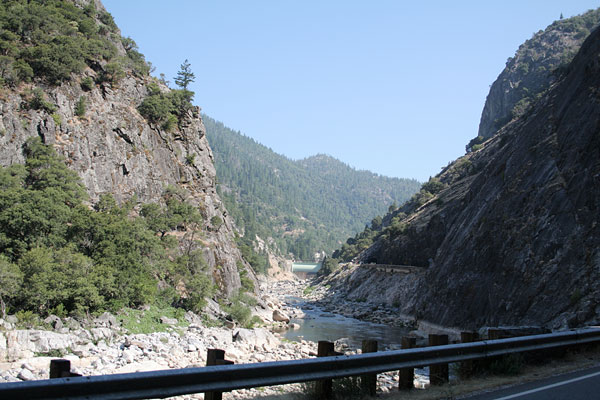
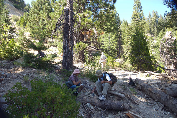
We stopped at the Rock Creek-Cresta Dam rest area along Highway 70 to observe the ecology and geology of the area. Regarding the ecology, we found typical lower Sierran montane coniferous forest (photo 5, right). Below the Cresta Dam, the river level was very low because the dam (photo 6), one of many on the North Fork of the Feather River constructed for generating hydroelectric power, controls the water flow. Above the dam, the river level was quite high (photo 7).
Near the dam, Route 70 passes through two tunnels (one can be seen in photo 8, left) that cut through Elephant Butte — this is part of Grizzly Dome, an exposed portion of the Mesozoic Grizzly Pluton, a surface exposure of granitic rock that is part of the Sierran batholith. On the opposite side of the river is Sugar Loaf Mountain, another exposed portion of the pluton.
The La Porte locality
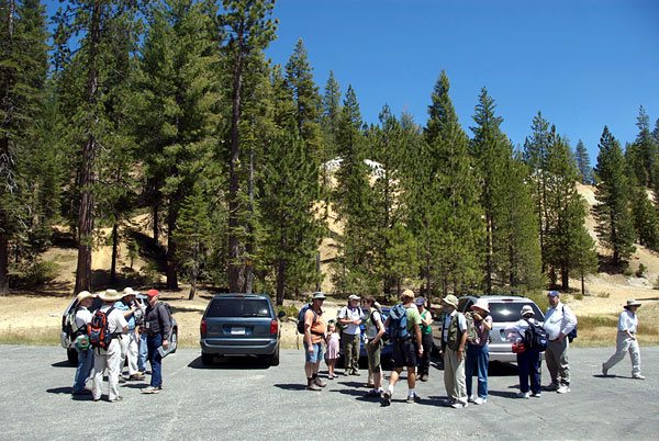
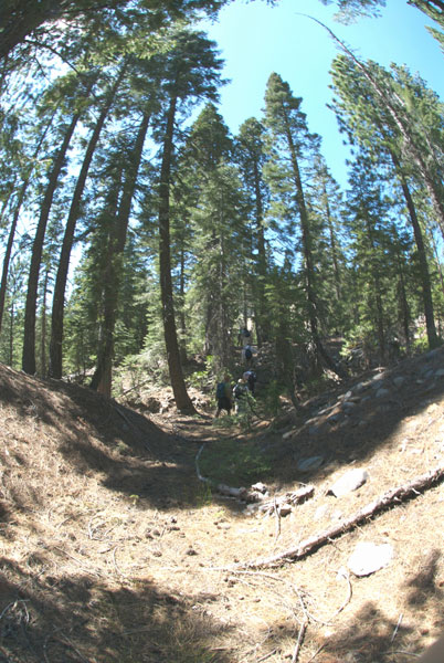
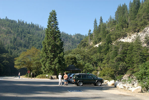
We rendezvoused just outside La Porte (photo 9). Here, the group prepared for the hike up to the late Eocene La Porte flora locality. On the hike to the locality, we passed through a conifer forest (photo 10) of primarily yellow (Pinus ponderosa), lodgepole (P. contorta), and sugar (P. lambertiana) pines with the occasional Douglas fir (Pseudotsuga menziesii), white fir (Abies concolor), and incense cedar (Calocedrus descurrens).
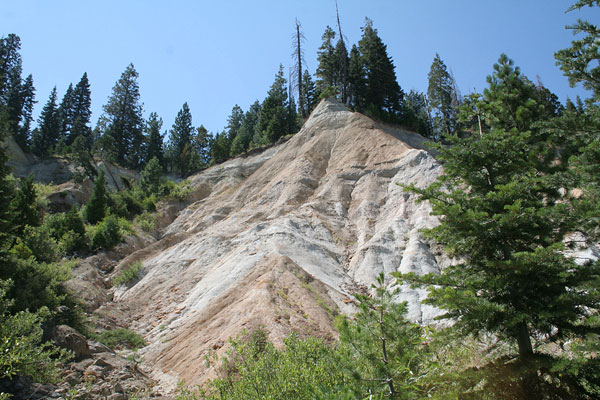
Before too long, the exposed cliff face came into view (photo 11, right). On the face, one can clearly see the stratification of the old paleochannels (photo 12). The late Eocene La Porte flora comes from the massive white La Porte Tuff, a lahar channel-fill deposit of rhyodacitic ash, near the top of the section (photo 13) and has a K-Ar date of 33.4 first obtained by Evernden and James in 1964 (Potassium-argon dates and the Tertiary floras of North America. American Journal of Science, 264:945-974), but has been recalibrated to 34.275, i.e., latest Eocene. Just below the tuff is the laminated mudstone and sandstone floodplain facies of the upper Ione Formation, which is 45 to 46 million years in age (middle Eocene) and mentioned earlier. The Gravels and overlying leaf-bearing tuff were deposited in the La Porte paleochannel, a southward directed channel that was part of the ancient Yuba River system. Geologist Larry Garside, who has been studying the paleocanyons in this region of the Sierra Nevada, has recently presented a nice poster (pdf) and published a paper (pdf) discussing the geology of these old Tertiary paleochannels. Read more about the geologic history of the northern Sierra Nevada.
Susan Potbury monographed the flora in 1935 (The La Porte flora of Plumas County, California. Carnegie Institute of Washington Publication no. 465:29-81). This appears to be a very careful work that has largely withstood the scrutiny of time. Potbury recognized 41 species assigned to 34 genera. From her comparison of the fossils to extant taxa, she grouped the fossils as 46% trees, 41% small trees or shrubs, and 13% vines. From analysis of the leaf characters such as size, and noting that 71% of the species are entire-margined vs. only 29% toothed, she concluded that the assemblage grew under a mean annual temperature of 24°C and an annual precipitation of 1650 mm, which is very similar to the 22°C CLAMP estimates by Jack Wolfe. Genera she recognized include the cycad Zamia, the conifer Amentotaxus (Taxaceae), a palm, Quercus, Ulmus, menispermes, laurels, Liquidambar, legumes, euphorb, Ilex, Meliosma, Rhamnaceae, Tiliaceae, Dilleniaceae, Cornus, Sapotaceae, Apocynaceae, and Verbenaceae.
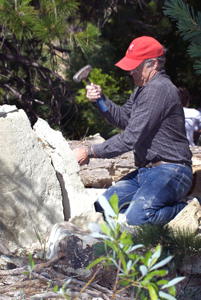
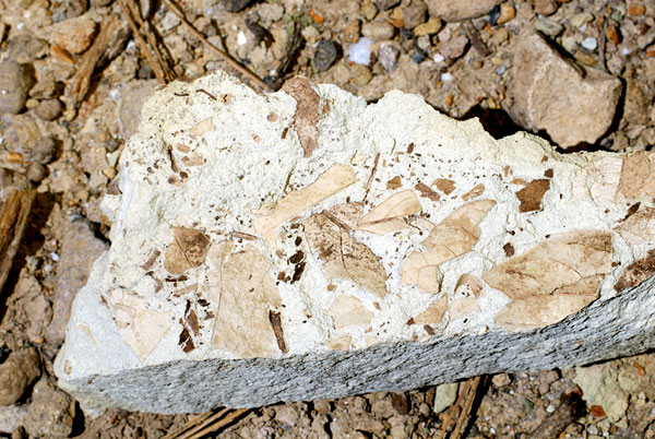
Collecting fossil plants here involves finding and splitting open pieces of the tuff layer that have weathered out and fallen down the hillside (photo 14, left). The group spread out near the base of the cliff to see what they could find (photo 15) in a safe area away from any potential rock fall.
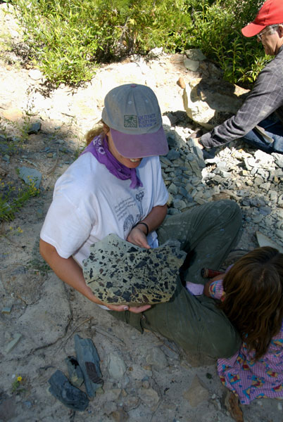
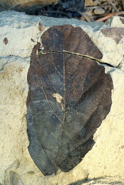
Some scientifically significant specimens were discovered. Greg Retallack's efforts with the sledge and chisel yielded a good-sized slab exhibiting leaves from a dicot-dominated forest that grew here in the late Eocene, 34.3 million years ago (photo 16). This is quite a contrast from the conifer-dominated forest growing in the area today. Paul Kester also found and donated to UCMP a beautiful slab that shows the diversity of the La Porte Tuff paleflora (photo 17). Many of the leaves in his slab look worn and fragmentary due to their incorporation into the tuff and their transport prior to deposition.
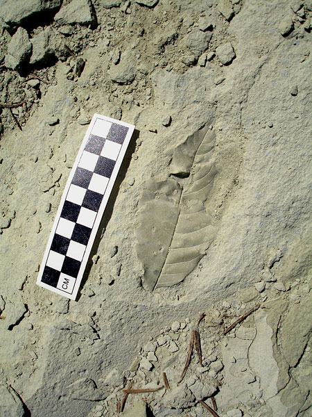
The leaves found on the freshly split surfaces of the La Porte tuffaceous rocks have to be collected and handled carefully because the cuticle is often preserved, indicated by the leaves' dark color. The La Porte leaves that are exposed to weathering from the elements lose the cuticle and are left as impressions in the rock. Although these specimens may still show the venation pattern, leaves with cuticle provide more detailed information about the leaf surface, such as epidermal cell shape, glands, trichomes, and stomata. These morphological features allow paleobotanists to directly compare the cuticles of fossil and modern leaves to determine the systematic affinities of the fossils. See Day 2 of
our trip to see how paleobotanists use characteristics of the stomata to determine paleoelevation of ancient mountain ranges.
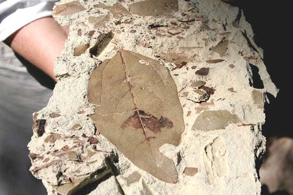
At right is a sampling of some of the significant specimens collected by the group. Photo 18 is of a nice slab showing remnants of leaves and twigs encased in the volcanic sediment. Photo 19 is of a nearly complete leaf (a rarity) similar to a type described in 1935 as Sterculia ovata in the family Sterculiaceae. This specimen, collected by Greg Retallack, is of additional scientific interest for the number and types of insect feeding traces it shows. It will be a new addition to the University of Oregon paleobotany collection. A second nearly complete specimen pictured in photo 20 displays a well-preserved cuticle and also has insect feeding traces. Photo 21 is of a leaf similar to fossil leaves described as Quercus nevadensis. In photo 22 we see a large, well-preserved coalified fruit or seed found by Virginia Friedman — it was found in the older carbonaceous shales of the Ione Formation. Bruce Tiffney of the UC Santa Barbara Geology Department has worked on the fruits and seeds from these La Porte sediments.
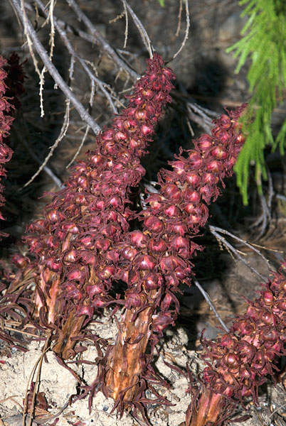
At the locality, we encountered the unusual flowering plant, Sarcodes sanquinea (photo 23, left). Torrey or snow plant is a member of the Indian pipe subfamily Monotropoideae within the family Ericaceae. As the name conveys, they are fleshy, with a red-colored flowering stalk. These plants lack the green pigment chlorophyll and therefore are non-photosynthesizing. They live as saprophytes in the humus of western North American montane conifer forests. Snow plants, unlike Monotropa species which are white, do have red pigment which gives them their brilliant red color. This dark color may aid in absorbing solar energy (warmth) allowing them to grow through the lingering northern Sierran mountain snows of early spring. Although the plants come up in the spring they can still be seen even in late summer, as we discovered.
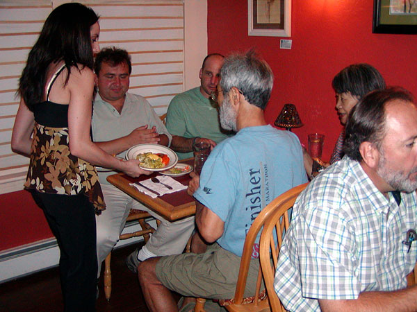
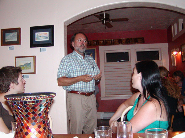
After cleaning up back at the hotel, the group dined at Café Le Coq, a French restaurant in Quincy. Here we were served a delicious 5-course meal with our choice of duck, salmon, sea bass, beef stew, or pork as a main dish (photo 24), all prepared by the owner and chef, Patrick Lecoq. Following dinner, Scott Lawson, Director of the Plumas County Museum (photo 25), spoke to us and fielded questions about his museum and some of the mining and cultural history of the Quincy area. Thanks again Patrick and Scott — this was a trip highlight! Thus concluded Day 1 of the field trip.