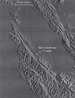
Overview of the Geological Forces That Shaped the San Francisco Bay
- San Andreas fault system and related tectonic (extension and compressional) forces.
- Local tectonic interactions between the regional blocks/subterranes, in addition to glacial-interglacial changes, are important in understanding the history of the Bay.
- Sedimentary basin processes: subsidence, sediment supply and sea level change.
- Late Pliocene and Quaternary sedimentation patterns: insights from the Merced and Colma formations.
| Click on the slides at left to zoom in as you read through the presentation. | |
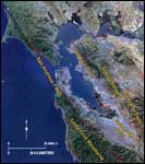 |
San Francisco Bay is a fault-bounded estuary, structurally controlled by the San Andreas transform fault to the west and to the east by the Hayward fault shown in the satellite image of San Francisco Bay. Note the numerous step-overs in the system of right lateral transform faults that border San Francisco Bay. Of particular interest is the right step between the Hayward fault and the Rodgers Creek fault (unlabeled, but it is shown just to the north east of the Hayward fault). Tension associated with movement along these two faults pulls apart the crust in the area of San Pablo Bay creating a topographic low and sedimentary basin. |
|
Right slip on transform fault with marked double bends results in pull apart basins at releasing bends (due a right step on the fault) and deformation/uplift at restraining bends (due to a left step on the fault). |
|
|
Differences in rates of slip along segments of the transform fault system result in complex compressional and extensional forces leading to the formation of structural highs (mountains) and lows (basins). This map highlights the geologic structure of the San Francisco Bay region as a complex series of subterranes or blocks which are bounded by faults. The Bay Block has been a topographic low for the last few million years. Visit the USGS San Francisco Bay Region Project web site to learn more about the geology of these structural blocks. |
|
|
This map shows the major Franciscan Complex terranes that form the basement rock in the Bay region. The simplified cross section beneath San Francisco Bay shows the thin veneer of Pleistocene Colma Formation that overlies the Franciscan Formation and also the Recent bay mud. |
|
|
This image from the USGS Digital Elevation Models and Bathymetry Images web site enhances the topographic, structure, and drainage features in the region. It also illustrates the close relationship between the position of the valleys and transform faults in the region. These topographic lows would be filled if sea level were higher as it was 125,000 years ago when the Colma Formation was deposited. |
|
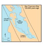 |
This paleogeographic map of the San Francisco Bay area 125,000 years ago from the work of K.R. Lajoie shows the depositional setting for the Colma Formation that was thought to have been deposited in a narrow straight or coastal embayment created by a right step in the main trace of the San Andreas fault. This coastal embayment was also thought to have been present during deposition of estuarine units in the Pliocene-Pleistocene Merced Formation. |
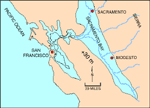 |
This figure, from the work of K.R. Lajoie, shows extent of flooding by rising sea level if greenhouse warming continues. Approximately one third of the world's volume of land-bound ice and snow would melt. The resulting rise would place sea level about 30 m above present sea level. |
 |
The S.F. Bay estuary's large watershed is illustrated in this map where river systems drain approximately 40% of the surface area of California. Rivers and tributaries that start in the Sierra Nevada join the Sacramento and San Joaquin rivers and eventually drain into the delta and San Francisco Bay. This drainage pattern has implications for the composition of the sediments that accumulate in the Bay and reflects erosion of igneous source rocks in the Sierra Nevada and sedimentary rocks of the Central Valley. These sediments deposit along the tidal marshes and mudflats of the Bay, |
|
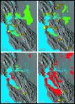
This image shows the effect of human activity and population growth in the S.F. Bay area during the period from 1850 to 1990. The green pattern shows open wetlands, and the red pattern shows growing population centers. Also shown are some of the major earthquakes (yellow dots) that have taken place. |
|


