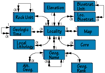
Legend

| Field Name | Description | 1º Key | 2º Index | Foreign Key | Paradox Field Type | |
| LocPrefix | Locality prefix. For compatibility with existing records | Alpha, 2 characters | ||||
| LocalityNo | Long Integer | |||||
| Geog | Location of site | Geography | Short Integer | |||
| MapName | Map on which locality is marked | Map | Alpha, 40 characters | |||
| GeolTime | Age of locality | GeolTime | Short Integer | |||
| RockUnitNo | Rock unit fossils were found in | RockUnit | Short Integer | |||
| LandownerNo | Property owner | Landowner | Long Integer | |||
| LocalityName | Alpha, 80 characters | |||||
| Latitude | Stored in decimal degrees | Number | ||||
| Longitude | stored in decimal degrees | Number | ||||
| Variance | Amount of uncertainty in latitude/longitude measurements | Alpha, 20 characters | ||||
| Township | Alpha, 3 characters | |||||
| Range | Alpha, 3 characters | |||||
| Sections | Alpha, 3 characters | |||||
| Meridian | Meridian referenced by Township Range Section values | Alpha, 25 characters | ||||
| Description | Description to enable relocation of locality | Memo, 50 characters displayed | ||||
| CollectDate | Date of first collection at locality | Alpha, 25 characters | ||||
| EntryDate | date record entered in database | Date | ||||
| EnteredBy | Data Entry personnel | Person | Long Integer |
| Field Name | Description | 1º Key | 2º Index | Foreign Key | Paradox Field Type | |
| BiozoneNo | Long Integer | |||||
| BiozoneName | Name of biozone unit. | Alpha field, 25 characters | ||||
| BiozoneParent | GeolTime | Long Integer |
| Field Name | Description | 1º Key | Foreign Key | Paradox Field Type | |
| LocPrefix | Locality | Alpha, 2 characters | |||
| LocalityNo | Locality | Long Integer | |||
| BiozoneNo | Biozones | Long Integer |
| Field Name | Description | 1º Key | Foreign Key | Paradox Field Type | |
| LocPrefix | Locality | Alpha, 2 characters | |||
| LocalityNo | Locality | Long Integer | |||
| Elev | Locality elevation, measured in meters | Alpha, 15 characters |
| Field Name | Description | 1º Key | 2º Index | Foreign Key | Paradox Field Type | |
| GeogNo | Long Integer | |||||
| GeogRankNo | GeogRank | Long Integer | ||||
| GeogName | Name of geographic entity | Alpha, 120 characters | ||||
| GeogParentNo | Recursive key for hierarchical relationship | Long Integer | ||||
| GeogAncestry | Simplifies SQL queries for hierarchical searches | Alpha, 40 characters |
| Field Name | Description | 1º Key | 2º Index | Foreign Key | Paradox Field Type | |
| GeogNo | Geography | Long Integer | ||||
| AltName | Alternate name of geographic entity (e.g. British West Africa) | Alpha, 120 characters |
| Field Name | Description | 1º Key | 2º Index | Foreign Key | Paradox Field Type | |
| GeogRankNo | Long Integer | |||||
| GeogRank | Rank of geographic entity (e.g., country, county). | Alpha, 60 characters |
| Field Name | Description | 1º Key | 2º Index | Foreign Key | Paradox Field Type | |
| TimeNo | Long Integer | |||||
| TimeUnit | Name of time or rock-time unit | Alpha, 80 characters | ||||
| ParentNo | Recursive key for hierarchical relationship | Long Integer | ||||
| TimeAncestry | Simplifies SQL queries for hierarchical searches | Alpha, 40 characters | ||||
| UpperpickMa | Age of upper limit of unit, in millions of years | Number | ||||
| LowerpickMa | Age of lower limit of unit, in millions of years. | Number | ||||
| Authority | Reference for time intervals | Reference | Long Integer |
| Field Name | Description | 1º Key | Foreign Key | Paradox Field Type | |
| LocPrefix | Locality | Alpha, 2 characters | |||
| LocalityNo | Used to maintain multiple lithologies per locality | Locality | Long Integer | ||
| LithologyNo | Short integer | ||||
| Lithology | Lithological description | Memo, 20 characters displayed |
| Field Name | Description | 1º Key | 2º Index | Foreign Key | Paradox Field Type | |
| MapName | Quad name (name of map) | Alpha, 40 characters | ||||
| MapNo | Long Integer | |||||
| MapSource | Map Publisher | Alpha, 25 characters | ||||
| MapEd | Edition of map | Alpha, 8 characters | ||||
| MapScale | Scale of map | Long Integer | ||||
| Projection | Alpha, 10 characters |
| Field Name | Description | 1º Key | 2º Index | Foreign Key | Paradox Field Type | |
| RockUnitNo | Long Integer | |||||
| UnitName | Name of rock unit (e.g. Hell Creek). | Alpha, 30 characters | ||||
| UnitRank | Rank of unit (e.g. Formation) | Alpha, 15 characters | ||||
| UnitParent | RockUnitNo of parent unit. Recursive key for hierarchical relationship | Long Integer | ||||
| UnitAncestry | Simplifies SQL queries for hierarchical searches | Alpha, 40 characters |
| Field Name | Description | 1º Key | Foreign Key | Paradox Field | |
| LocPrefix | Locality | Alpha, 2 characters | |||
| LocalityNo | Locality | Long Integer | |||
| Locality Suffix | Used to denote different cores from a locality | Alpha, 80 characters | |||
| CoreDepth | Measured in metric units. | Alpha, 15 characters |