
|
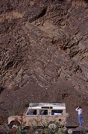
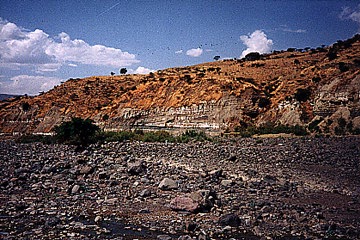
Fig. 4 - Geology and Stratigraphy.
At left, massive Eocene basalt (lava) flows cap the rim of the Blue Nile Gorge. The columnar jointing structure is formed as a result of contraction during cooling of the basalt. At right, a view of the Mugher River Valley.
Dominantly terrestrial sediments in the study area were formally assigned by Getaneh (1991) to two formations, the Mugher Mudstone and the overlying Debre Libanos Sandstone. These lie above the Lagajima Limestone and are overlain unconformably by Tertiary basalts. The Mugher Mudstone, which reaches a thickness of some 320 m in the region of Lemi, thins westward to 15 m in the vicinity of Gohatsion. Sedimentological studies by Getaneh (1991) showed that the lower Mugher Mudstone was composed of a series of subtidal and lagoonal deposits. These grade upward into muddy, fine-grained, meandering river deposits reaching 244 m in thickness that appear to have been deposited under dry, semiarid conditions with a climate probably characterized by seasonal rainfall and occasional prolonged droughts.
The ages of the Mugher Mudstone and Debre Libanos Sandstone are constrained by the underlying early Kimmeridgian Lagajima Limestone and the unconformably overlying basalts that began to be deposited in the Eocene. Algal mats and burrow structures in the lower Mugher Mudstone and fossil wood in the upper Mugher Mudstone and the Debre Libanos Sandstone provide no data of biochronological significance. Provisionally the two formations have been treated as being of Late Jurassic to Early Cretaceous age.
| Era | Formation | Th. | Lithology | Facies | Localities |
|---|---|---|---|---|---|
| T | unnamed basalt | 5,500 | basalt, trachyte, rhyolite with beds of tuff, paleosols, & lacustrine sediments | ||
| K | Debre Libanos Ss | 280 | fine to medium-grained ss with local lenses of claystone and conglomerates | braided river system on broad alluvial plain | |
| -?- | Mugher Mudstone | 320 | alternating fine-grained ss, mudstones with beds of siltstones and shale at top; interbedded dolomites, gypsum and shale at the bottom | upper: muddy, fine-grained meandering stream lower: supratidal & lagoonal environment |
2, 3, 4, 5, 6 |
| Ju | Lagajima Ls (Antalo Ls) |
420 | fossiliferous ls with beds of shale and marl | shallow water; oolitic bars, coral patch | |
| Gohatsion Ls | 450 | cyclic shale, gypsum & dolostone at top; interbedded siltstone & mudstone at bottom | peritidal with associated lagoonal and pond bodies; mixed marine/freshwater | ||
| Tr | Adigrat Sandstone | 300 | sandstone, siltstone, & shale in upper beds; shale in lower beds fining uppward sequence, cross-stratification | fluviatile, multi-storied channels, pebble-filled lags with fossil wood | ? 1 |
Fig. 5 - Stratigraphy of the Region.
Chart showing the relationships and characteristics of the formations in the area studied. Th.=maximum thickness in meters, Ls=limestone, Ss=sandstone. Modified from Getaneh 1991 and Russo et al. 1994.