Plate tectonics
The progress of the Earth Sciences and the advancement of technologies associated with the understanding of our planet during the 1940s and 1950s have led geologists to develop a new way of looking at the world and how it works. We provide a bit about the history of our new understanding of the Earth and present a brief overview of the theories behind it.
The history of an idea
Close examination of a globe often results in the observation that most of the continents seem to fit together like a puzzle: the west African coastline seems to snuggle nicely into the east coast of South America and the Caribbean sea; and a similar fit appears across the Pacific. The fit is even more striking when the submerged continental shelves are compared rather than the coastlines. In 1912 Alfred Wegener (1880-1930) noticed the same thing and proposed that the continents were once compressed into a single protocontinent which he called Pangea (meaning "all lands"), and over time they have drifted apart into their current distribution. He believed that Pangea was intact until the late Carboniferous period, about 300 million years ago, when it began to break up and drift apart. However, Wegener's hypothesis lacked a geological mechanism to explain how the continents could drift across the Earth's surface as he proposed.
Searching for evidence to further develop his theory of continental drift, Wegener came across a paleontological paper suggesting that a land bridge had once connected Africa with Brazil. This proposed land bridge was an attempt to explain the well known paleontological observation that the same fossilized plants and animals from the same time period were found in South America and Africa. The same was true for fossils found in Europe and North America, and Madagascar and India. Many of these organisms could not have traveled across the vast oceans that currently exist. Wegener's drift theory seemed more plausible than land bridges connecting all of the continents. But that in itself was not enough to support his idea. Another observation favoring continental drift was the presence of evidence for continental glaciation in the Pensylvanian period. Striae left by the scraping of glaciers over the land surface indicated that Africa and South America had been close together at the time of this ancient ice age. The same scraping patterns can be found along the coasts of South America and South Africa.
Wegener's drift hypothesis also provided an alternate explanation for the formation of mountains (orogenesis). The theory being discussed during his time was the "Contraction theory" which suggested that the planet was once a molten ball and in the process of cooling the surface cracked and folded up on itself. The big problem with this idea was that all mountain ranges should be approximately the same age, and this was known not to be true. Wegener's explanation was that as the continents moved, the leading edge of the continent would encounter resistance and thus compress and fold upwards forming mountains near the leading edges of the drifting continents. The Sierra Nevada mountains on the Pacific coast of North America and the Andes on the coast of South America were cited. Wegener also suggested that India drifted northward into the Asian continent thus forming the Himalayas.
Wegener eventually proposed a mechanism for continental drift that focused on his assertion that the rotation of the Earth created a centrifugal force towards the equator. He believed that Pangea originated near the south pole and that the centrifugal force of the planet caused the protocontinent to break apart and the resultant continents to drift towards the equator. He called this the "pole-fleeing force." This idea was quickly rejected by the scientific community primarily because the actual forces generated by the rotation of the Earth were calculated to be insufficient to move continents. Wegener also tried to explain the westward drift of the Americas by invoking the gravitational forces of the sun and the moon, this idea was also quickly rejected. Wegener's inability to provide an adequate explanation of the forces responsible for continental drift and the prevailing belief that the Earth was solid and immovable resulted in the scientific dismissal of his theories.
In 1929, about the time Wegener's ideas began to be dismissed, Arthur Holmes elaborated on one of Wegener's many hypotheses; the idea that the mantle undergoes thermal convection. This idea is based on the fact that as a liquid is heated its density decreases — this less-dense liquid rises to the surface until it is cooled and sinks again. This repeated heating and cooling results in a current which may be enough to cause continents to move. Arthur Holmes suggested that this thermal convection was like a conveyor belt and that the upwelling pressure could break apart a continent and then force the broken continent in opposite directions carried by the convection currents. This idea received very little attention at the time.
Not until the 196's did Holmes' idea receive any attention. Greater understanding of the ocean floor and the discoveries of features like mid-oceanic ridges, geomagnetic anomalies parallel to the mid-oceanic ridges, and the association of island arcs and oceanic trenches occurring together and near the continental margins, suggested convection might indeed be at work. These discoveries and more led Harry Hess (1962) and R. Deitz (1961) to publish similar hypotheses based on mantle convection currents, now known as "sea floor spreading." This idea was basically the same as that proposed by Holmes over 30 years earlier, but now there was much more evidence to further develop and support the idea.
The mechanism
The main features of plate tectonics are:
Advances in sonic depth recording during World War II and the subsequent development of the nuclear resonance type magnometer (proton-precession magnometer) led to detailed mapping of the ocean floor and with it came many observations that led scientists like Howard Hess and R. Deitz to revive Holmes' convection theory. Hess and Deitz modified the theory considerably and called the new theory "sea-floor spreading." Among the seafloor features that supported the sea-floor spreading hypothesis were: mid-oceanic ridges, deep sea trenches, island arcs, geomagnetic patterns, and fault patterns.
Mid-oceanic ridges
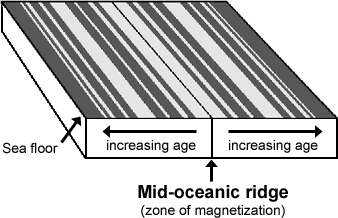
The mid-oceanic ridges rise 3000 meters from the ocean floor and are more than 2000 kilometers wide, surpassing the Himalayas in size. The mapping of the seafloor also revealed that these huge underwater mountain ranges have a deep trench which bisects the length of the ridges and in places is more than 2000 meters deep. Research into the heat flow from the ocean floor during the early 1960s revealed that the greatest heat flow was centered at the crests of these mid-oceanic ridges. Seismic studies show that the mid-oceanic ridges experience an elevated number of earthquakes. All these observations indicate intense geological activity at the mid-oceanic ridges.
|
Deep sea trenches
The deepest waters are found in oceanic trenches, which plunge as deep as 35,000 feet below the ocean surface. These trenches are usually long and narrow, and run parallel to and near the oceans margins. They are often associated with and parallel to large continental mountain ranges. There is also an observed parallel association of trenches and island arcs. Like the mid-oceanic ridges, the trenches are seismically active, but unlike the ridges they have low levels of heat flow. Scientists also began to realize that the youngest regions of the ocean floor were along the mid-oceanic ridges, and that the age of the ocean floor increased as the distance from the ridges increased. In addition, it has been determined that the oldest seafloor often ends in the deep-sea trenches.
Island arcs
Chains of islands are found throughout the oceans and especially along the western margin of the Pacific; the Aleutians, Kuriles, Japan, Ryukus, Philippines, Marianas, Indonesia, Solomons, New Hebrides, and the Tongas, are some examples. These "island arcs" are usually situated along deep sea trenches and are situated on the continental side of the trench.
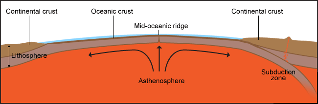 |
These observations, along with many other studies of our planet, support the theory that underneath the Earth's crust (the lithosphere: a solid array of plates) is a malleable layer of heated rock known as the asthenosphere which is heated by radioactive decay of elements such as uranium, thorium, and potassium. Because the radioactive source of heat is deep within the mantle, the fluid asthenosphere circulates as convection currents underneath the solid lithosphere. This heated layer is the source of lava we see in volcanoes, the source of heat that drives hot springs and geysers, and the source of raw material which pushes up the mid-oceanic ridges and forms new ocean floor. Magma continuously wells upwards at the mid-oceanic ridges producing currents of magma flowing in opposite directions and thus generating the forces that pull the sea floor apart at the mid-oceanic ridges. As the ocean floor is spread apart, cracks appear in the middle of the ridges allowing molten magma to surface through the cracks to form the newest ocean floor. As the ocean floor moves away from the mid-oceanic ridge it will eventually come into contact with a continental plate and will be subducted underneath the continent. Finally, the lithosphere will be driven back into the asthenosphere where it returns to a heated state.
Continue your exploration of geologic time:
* Dates from the International Commission on Stratigraphy's International Stratigraphic Chart, 2009.
W. Brian Simison created this page, 8/22/1997, and Anne Weil reviewed it; Dave Smith eliminated the plate tectonics animations since newer, better versions are now available, adapted the page to the new site format, and made minor edits, 7/11/2011