A MODEL OF SEA-FLOOR
SPREADING TEACHER'S GUIDE
ELLEN P. METZGER
INTRODUCTION
Purpose: Students will make a paper model illustrating the concept of sea-floor
spreading and the development of symmetrical magnetic "stripes" on either side of a mid-
ocean spreading center.
Suggested Student Grouping: Students work as individuals.
Framework Integration: Themes: Patterns of change: over time, new sea-floor is
created by the upwelling of magma at mid-ocean spreading centers; old ocean floor is
destroyed by subduction at deep sea trenches. Science skills and processes: Inferring from a
model. Integrating with other disciplines: Physical science: dipole magnets and magnetic
fields; convection. Oceanography: topography of the ocean floor. Life Science: animals
found at hot-water vents on the ocean floor.
Related Activities: Submarine Mountains.
BACKGROUND INFORMATION
Before performing this activity, students should be familiar with:
1) types of boundaries between lithospheric plates;
2) features of the ocean floor;
3) the concept of sea-floor spreading; and
4) the nature of the Earth's magnetic field and the fact that it has reversed its polarity many
times in the past.
The Earth's layers — The Earth is a layered planet consisting of crust, mantle and
core (Fig. 1). The outer 100 km or so is a rigid layer called the lithosphere, which is made up
of the crust and uppermost mantle. The lithosphere is broken into a number of large and small
plates that move over the asthenosphere, a plastic layer in the upper mantle. Earthquakes and
volcanoes are concentrated at the boundaries between lithospheric plates. It is thought that
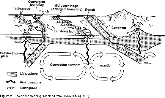
plate movement is caused by convection currents in the mantle (Fig. 2), although the exact
mechanism is not known. Lithosphere plates are moving at rates of a few cm per year.

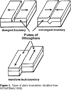
Types of plate boundaries — There are three types of boundaries between
lithospheric plates (Fig. 3):
1) convergent boundary — plates converge, or come together. If a plate of oceanic lithosphere collides with thicker and less dense continental lithosphere, the denser oceanic plate will dive beneath the continent in a subduction zone (Fig. 2).
2) divergent boundary — two plates diverge, or move apart and new crust or lithosphere is formed.
3) transform fault boundary — plates slide past one another with no creation or destruction of lithosphere.
 Return to top Return to top
The Ocean Floor — A map of the ocean floor shows a variety of topographic features: flat plains, long mountain chains, and deep trenches. Mid-ocean ridges are part of chain of mountains some 84,000 km long. The Mid-Atlantic Ridge is the longest mountain chain on Earth. These ridges are spreading centers or divergent plate boundaries where the upwelling of magma from the mantle creates new ocean floor.
Deep-sea trenches are long, narrow basins which extend 8-11 km below sea level. Trenches develop adjacent to subduction zones, where oceanic lithosphere slides back into the mantle (Fig. 2).
Continental drift — The idea that continents move is an old one; Alfred Wegener, a German meteorologist, proposed the hypothesis of continental drift. in the early 1900's.
Wegener used several lines of evidence to support his idea that the continents were once
joined together in a supercontintent called Pangaea and have since moved away from one another: (1) the similarity in shape of the continents, as if they once fit together like the pieces of a jigsaw puzzle; (2) the presence of fossils such as Glossopteris, a fossil fern whose spores could not cross wide oceans, on the now widely-separated continents of Africa, Australia, and India; (3) the presence of glacial deposits on continents now found near the equator; and (4) the similarity of rock sequences on different continents.
Return to top
Wegener's hypothesis of continental drift was not widely accepted because he had no
mechanism to explain how the continents move. The idea was not revived until new
technology made exploration of the ocean floor possible.
Sea-floor spreading — In the early 1960s, Princeton geologist Harry Hess proposed the hypothesis of sea-floor spreading, in which basaltic magma from the mantle rises to create new ocean floor at mid-ocean ridges. On each side of the ridge, sea floor moves from the ridge towards the deep-sea trenches, where it is subducted and recycled back into the mantle (Fig. 2). A test of the hypothesis of sea-floor spreading was provided by studies of the Earth's magnetism.
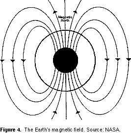
The Earth's Magnetic Field — The Earth's magnetic field is thought to arise from the movement of liquid iron in the outer core as the planet rotates. The field behaves as if a
permanent magnet were located near the center of the Earth, inclined about 11 degrees from
the geographic axis of rotation (Fig. 4). Note that magnetic north (as measured by a compass)
differs from geographic north, which corresponds to the planet's axis of rotation.
Placing a bar magnet beneath a piece of paper with iron filings on it will create a pattern as
the filings align themselves with the magnetic field generated by the magnet. The Earth's
magnetic field is similar to that generated by a simple bar magnet. At present, the lines of
force of the Earth's magnetic field are arranged as shown in Figure 4; the present orientation
of the Earth's magnetic field is referred to as normal polarity. In the early 1960s,
geophysicists discovered that the Earth's magnetic field periodically reverses; i.e. the north
magnetic pole becomes the south pole and vice versa. Hence, the Earth has experienced
periods of reversed polarity alternating with times (like now) of normal polarity. Although
the magnetic field reverses at these times, the physical Earth does not move or change its
direction of rotation.
Basaltic lavas contain iron-bearing minerals such as magnetite which act like compasses.
That is, as these iron-rich minerals cool below their Curie point, they become magnetized in
the direction of the surrounding magnetic field. Studies of ancient magnetism
(paleomagnetism) recorded in rocks of different ages provide a record of when the Earth's
magnetic field reversed its polarity.
Return to top
During World War II, sensitive instruments called magnetometers were developed to help
detect steel-hulled submarines. When research scientists used magnetometers to study the
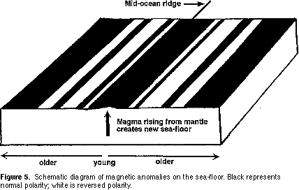
ocean floor, they discovered a surprising pattern. Measurements of magnetic variations
showed that, in many areas, alternating bands of rocks recording normal and reversed polarity
were arranged symmetrically about mid-ocean ridges (Fig. 5).
In 1963, F. Vine and D.H. Matthews reasoned that, as basaltic magma rises to form new
ocean floor at a mid-ocean spreading center, it records the polarity of the magnetic field
existing at the time magma crystallized. As spreading pulls the new oceanic crust apart,
stripes of approximately the same size should be carried away from the ridge on each side
(Fig. 5). Basaltic magma forming at mid-ocean ridges serves as a kind of "tape recorder",
recording the Earth's magnetic field as it reverses through time. If this idea is correct,
alternating stripes of normal and reversed polarity should be arranged symmetrically about
mid-ocean spreading centers. The discovery of such magnetic stripes provided powerful
evidence that sea-floor spreading occurs.
The age of the sea-floor also supports sea-floor spreading. If sea-floor spreading operates, the
youngest oceanic crust should be found at the ridges and progressively older crust should be
found in moving away from the ridges towards the continents. This is the case. The oldest
known ocean floor is dated at about 200 million years, indicating that older ocean floor has
been destroyed through subduction at deep-sea trenches.
It took exploration of the ocean floor to discover sea-floor spreading, the mechanism for the
movement of continents that Alfred Wegener lacked. The hypothesis of continental drift
gained renewed interest and, when combined with sea-floor spreading, led to the theory of
plate tectonics. The history of thought about the movement of continents provides a
wonderful example of how hypotheses such as continental drift and sea-floor spreading are
thoroughly tested before a new theory emerges. For an overview of the history of plate
tectonics, see Tarbuck and Lutgens (1994).
Return to top
MATERIALS (Sources given below)
— Maps of the ocean floor
— "This Dynamic Planet" map
For each student:
— 2 sheets of 8.5 x 11" binder paper (file folder cardboard could be used in place of paper to make a sturdier model)
— scissors
— ruler
— transparent tape
— masking tap
— colored pencils or crayons Suggestion: Make your own model ahead of time to show
students before they make their models.
SOURCES OF MATERIALS
Maps of the Arctic, Atlantic, Pacific, and Indian Ocean floors are available from the National
Geographic Society, Educational Services, P.O. Box 98019, Washington, D.C., 20090-8019;
phone 1-800-368-2728. Each map costs $10.90.
From Fisher-EMD: (1) Phosphorescent map of the ocean floor: measures 24" X 24" ($10.60);
(2) wall size Mid-Atlantic ridge map ($27.40). Order from Fisher Scientific-EMD, 4901 W.
Lemoyne Street, Chicago, IL 60651; phone 1-800-955-1177.
"This Dynamic Planet: World Map of Volcanoes, Earthquakes, and Plate Tectonics" — measures 150 x 100 cm; developed by the United States Geological Survey and the
Smithsonian Institution. Order from USGS Map and Book Distribution, P.O. Box 25286,
Federal Center, Bldg.. 810, Denver, CO 80225; phone 303-236-7477. The price is $3.00.
Return to top
PROCEDURES
Follow the steps on the student activity sheets. Students can measure the placement of
subduction zones and the mid-ocean ridge for their model as shown in Figure 1 in the student
activity sheets, or you can give them the ready-made template provided. You may wish to
copy the template onto file folder or similar cardboard for a sturdier model.
Modifications: For younger children, omit explanation of magnetic stripes and
reversals of polarity. Use the model to show them the creation of new sea floor at spreading
centers and the disappearance of old sea-floor at subduction zones. You may wish to cut the
paper model pieces for the students ahead of time, or use a model you have made as a
demonstration for the class.
Extensions: Hydrothermal vent systems, called black and white smokers, found at
oceanic spreading centers are one of the most exciting discoveries made during the last
fifteen years of marine exploration. These smokers are the sites of mineral deposits and
unique ecosystems that exist in total darkness. Integrate a unit on sea-floor spreading and
ocean floor topography with biology by having students research the unique creatures
associated with hydrothermal vent communities. Some suggested references are given below.
REFERENCES AND RESOURCES
NSTA/FEMA, 1988, Tremor Troop Earthquakes: National Science Teachers' Association,
Washington, D.C.
Tarbuck, E. J. and Lutgens, F. K., 1994, Earth Science (7th ed.), Macmillan Publishing
Company, p. 207-242.
General information:
Yulsman, T., 1993, Charting Earth's Final Frontier: Earth, vol. 2, no. 4 (July 1993), p. 36-41.
Discusses mapping of volcanoes, faults, canyons, and lava flows on the ocean floor using a
side-scan sonar device called GLORIA (Geologic Long-Range Inclined Asdic).
The General Interest Publication "Marine Geology: Research Beneath the Sea" from the
United States Geological Survey provides an overview of the methods and equipment that
marine geologists employ to study the ocean floor. The pamphlet describes studies of ocean
floor topography, sediments and mineral resources. Order up to 50 free copies (use school
letterhead) from theUnited States Geological Survey, Box 25286, Denver Federal Center,
Bldg. 810, Denver CO 80225; phone (303)236-7476.
For Younger Children:
Cole, J., 1992, The Magic School Bus on the Ocean Floor: Scholastic, Inc., New York. The
kids in Mrs. Frizzle's class take a field trip to the deep ocean floor to study animal and plant
life, a hot-water vent, and a coral reef (for elementary school children).
About Deep Sea Hydrothermal Systems:
Ballard, R. D. and Grassle, J. F., 1979, Incredible World of the Deep-sea Rifts: National
Geographic, v. 156, No. 5 (Nov. 1979), p. 680-705.
Lutz, R. A. and Hessler, R. R., 1983, Life Without Sunlight - Biological Communities of
Deep-Sea Hydrothermal Vents: The Science Teacher, v. 50, No. 3 (March 1983), p. 22-29.
Tunnicliffe, V., 1992, Hydrothermal-Vent Communities of the Deep Sea: American Scientist,
v. 80 (July-August, 1992), p. 336-349.
Return to top
Videos:
"Treasures of Neptune: Klondike on the Ocean Floor" ($149.00; 26 min). Looks at the
relationship between plate tectonics and marine mineral deposits; shows how the ocean floor
is being mapped and looks at recovery systems for marine resources including underwater
scoops and shovels and giant "vacuum cleaners". Order from Films for the Humanities &
Sciences, P.O. Box 2053; Princeton, N. J. 08543-2053; phone 1-800-257-5126. "The Last
Frontier on Earth" ($79.00; 26 min.). shows how scientists are exploring the sea floor using
Side Scan Sonar mapping and deep sea drilling. Order from: Brittanica Learning Materials,
Customer Service, 310 South Michigan Avenue, Chicago, IL 60604-9839; phone 1-800-554-
9862.
"Physical Oceanography" ($59.95; 19 min.). Describes methods of exploring the oceans;
interaction of oceans with the biosphere, lithosphere, and atmosphere to create a unique
environment; and the three main characteristics of oceans: their chemistry, topography, and
movement of water. Order from Scott Resources, P.O. Box 2121K, Ft. Collins, CO, 80522;
phone 1-800-289-9299.
Slides:
"Undersea Exploration" ($16.00 for 22 slides). This set illustrates submarine research using
deep water submersibles and remotely operated vehicles to study ocean floor rift systems.
Includes photos of black smokers, tube worms, and equipment used by oceanographers.
Order from the American Geophysical Union, Attn.: Orders, 2000 Florida Avenue, N.W.,
Washington, D.C. 20009; phone 1-800-966-2481.
Some Related Activities:
The Crustal Evolution Education (CEEP) module, "How Fast Is the Ocean Floor Moving?"
was developed by the National Association of Geology Teachers. In this module students
examine data from sediments on the ocean floor, determine whether the data support the
theory of sea-floor spreading, and calculate the rate of spreading of the East Pacific Rise.
Other CEEP modules related to the ocean floor include: "Lithospheric Plates and Ocean
Basin Topography"; "Microfossils, Sediments, and Sea-Floor Spreading"; "Movement of the
Pacific Ocean Floor"; "A Sea-Floor Mystery: Mapping Polarity Reversals"; and "Plotting the
Shape of the Ocean Floor". Each of these modules is available as a class pack which includes
a Teacher's Guide and 30 student investigation booklets and costs $23.50. Order from Ward's
Natural Science Establishment, Inc., 5100 West Henrietta Road, P.O. Box 92912, Rochester,
New York 14692-9012; phone 1-800-962-2260.
GLOSSARY
asthenosphere — a portion of the mantle which underlies the lithosphere. This zone
consists of easily deformed rock and in some regions reaches a depth of 700 km.
continental drift — The first hypothesis proposing large horizontal motions of
continents. This idea has been replaced by the theory of plate tectonics.
convergent plate boundary — a boundary between two lithospheric plates that move
towards each other. Such boundaries are marked by subduction, earthquakes, volcanoes, and
mountain-building.
Curie point — the temperature (about 580 degrees C) above which a rock loses its
magnetism.
deep-sea trenches — long, narrow, and very deep (up to 11 km) basins oriented
parallel to continents and associated with subduction of oceanic lithosphere.
divergent plate boundary — a boundary between two plates that move away from one
another; new lithosphere is created between the spreading plates.
lithosphere — the rigid, outermost layer of the Earth; includes crust and uppermost
mantle and is about 100 km thick.
mid-ocean ridge — a continuous mountain chain on the floor of all major ocean basins
which marks the site where new ocean floor is created as two lithospheric plates move away
from one another.
normal polarity — a magnetic field that has the same direction as the Earth's present
one.
paleomagnetism — the permanent magnetization recorded in rocks that allows
reconstruction of the Earth's ancient magnetic field.
Pangaea or Pangea — the proposed "supercontinent" that began to break apart 200
million years ago to form the present continents.
plate tectonics — the theory that proposes that the Earth's lithosphere is broken into
plates that move over a plastic layer in the mantle. Plate interactions produce earthquakes,
volcanoes, and mountains.
reversed polarity — a magnetic field with direction opposite to that of the Earth's
present field.
transform plate boundary — a boundary between lithosphere plates that slide past one
another.
sea-floor spreading — a hypothesis, proposed in the early 1960s, that new ocean floor
is created where two plates move away from one another at mid-ocean ridges.
subduction zone — a long, narrow zone where one lithospheric plate descends
beneath another.
Return to top
A MODEL OF SEA-FLOOR SPREADING
INTRODUCTION: The creation of new sea-floor at mid-ocean spreading centers
and its destruction in subduction zones is one of the many cycles that causes the Earth to
experience constant change.
PURPOSE: The purpose of this activity is to make a simple model that shows the
evolution of oceanic crust through sea-floor spreading and subduction.
MATERIALS:
— 2 sheets of 8.5" x 11" paper (cardboard may be substituted for 1 of the sheets)
— ruler
— colored pencils or crayons
— scissors
— transparent tape
— masking tape
PROCEDURES: If your teacher gives you a ready-made template for this activity,
skip steps 1-4.
1) Place one sheet of binder paper so that the long side is towards you (Fig. 1).
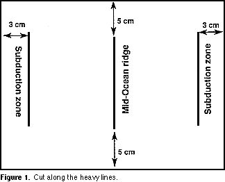
2) Draw a vertical line in the middle of the paper with a height of 11.5 cm leaving 5 cm on
either side of the line. This line represents a mid-ocean spreading center (See Figure 1).
3) Draw a second vertical line to the right of the center line so that it lies 3 cm from the right edge of the paper. This line represents a subduction zone.
4) Draw a third vertical line to the left of the center line so that it lies 3 cm from the left edge of the paper. This line represents another subduction zone. When you are finished, your piece of paper should look like the diagram in Figure 1.
Label the mid-ocean ridge and subduction zones.
5) With a pair of scissors, cut the vertical lines so there will be three slits on the paper all the same height and parallel to each other. To reinforce the slits you have made, place masking tape over each one and re-cut the slit though the tape.
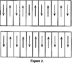
6) On the second sheet of paper draw 11 bands each 2.54 cm (1 "wide) perpendicular to the
long edge of the paper.
7) Choose one color to represent normal polarity and a second to represent reversed polarity.
Color alternate bands to represent periods of normal and reversed polarity. Color the band on
the far left as reversed polarity.
8) Cut the paper in half parallel to the long edge to get two strips of paper as shown in Figure
2. Mark the bands on each strip with arrows to indicate alternating periods of normal (up
arrow) and reversed (down arrow) polarity.
Return to top
 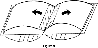
9) Insert one end of each strip of paper through the spreading center line on your first piece of paper (see Figure 3).
10) Pull each strip of paper towards the slits nearest the margins of the paper (the subduction zones). Tape each strip to make a loop as shown in Figure 3.
11) Circulate the ribbons of paper (which represent oceanic crust) to simulate the movement
of ocean floor from the mid-ocean spreading center to the subduction zone.
Start the movement of the ribbons with bands representing normal polarity.
QUESTIONS:
1) The Earth is about 4.6 billion years old. Based on observations of your sea-floor spreading
model, why do you think that the oldest ocean floor is only about 200 million years old?
2) On the real ocean floor, alternating stripes of normal and reversed polarity are not all of
equal width. What does this tell you about the lengths of time represented by normal and
reversed polarity?

|