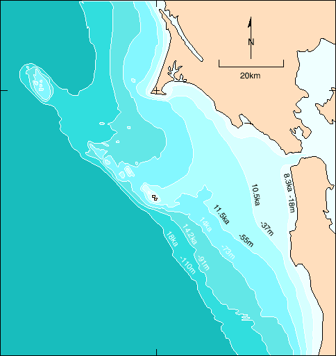
Features of San Francisco Bay: From River Valley to Estuary , Figure 8
The rise of the ocean level on the continental shelf after the last major global glaciation, from ~18 ka until ~8 ka. A long stillstand of sea level occurred during this rise at about 11.5 ka, as indicated by widespread, thick, nearshore deposits and gravel and sand presently at ~55 m depth.
Source: San Andreas Fault and Coastal Geology, from Half Moon Bay to Fort Funston-Crustal Motion, Climate Change, and Human Activity by Andersen D., Sarna-Wojcicki, A., Sedlock, R. (2001). In: Stoffer, Philip W. and Gordon, Leslie C. 2001 (eds.). Geology and Natural History of the San Francisco Bay Area, A Field-Trip Guidebook. U.S. Geological Survey, Bulletin 2188. Field Trip 4, pp. 87-104. (Fig. 4.6)
Back
updated April 3, 2002
UCMP Home | What's new | About UCMP | History of Life | Collections | Subway
![]()