Bay Area Geography and Geology, Figure 5
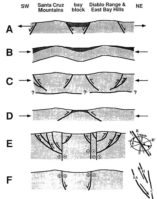
Sketch models of origin of San Francisco Bay depression and adjacent ranges. Heavy lines indicate faults. Darker shaded pattern indicates late Cenozoic basin fill. A. NE-SW extension, with bay block as a northwest-trending graben. B. Crustal flexure due to NE-SW compression. C. Crustal thickening and range uplift due to NE-SW compression and thrusting; thrusts may root into subhorizontal detachment in middle to lower crust. D. Crustal thickening, range uplift, and loading of bay block due to NE-SW compression and thrusting. E. Wrenching, with thrusts and fold trends at 10°-45° to strike-slip faults; inset shows schematic map view of structural trends (Sylvester, 1988). F. SPeculative origin of bay block as a large pull-apart basin between San Andreas and Hayward faults. Inset shows schematic map view of San Andreas (SA), Hayward (H), and Calaveras (C) faults.
Source: Anna V. Buising and James P. Walker, 1995, Preliminary palinspastic paleogeographic reconstructions for the greater San Francisco Bay area, in E. M. Sangines, D. W. Andersen, and A. V. Buising, eds., Recent geologic studies in the San Francisco Bay area, Pacific Section SEPM, volume 76, p. 141-159.
updated April 3, 2002
UCMP Home | What's new | About UCMP | History of Life | Collections | Subway
![]()