

The Cambrian follows the Vendian period, during which time the continents had been joined in a single supercontinent called Rodinia (from the Russian word for "homeland", rodina). As the Cambrian began, Rodinia began to fragment into smaller continents, which did not always correspond to the ones we see today. The reconstruction below shows the rifting of Rodinia durring the Tommotian. Green represents land above water at this time, red indicates mountains, light blue indicates shallow seas of the continental shelves, and dark blue denotes the deep ocean basins. (For clarity, the outlines of present-day continents have been superimposed on the map.)
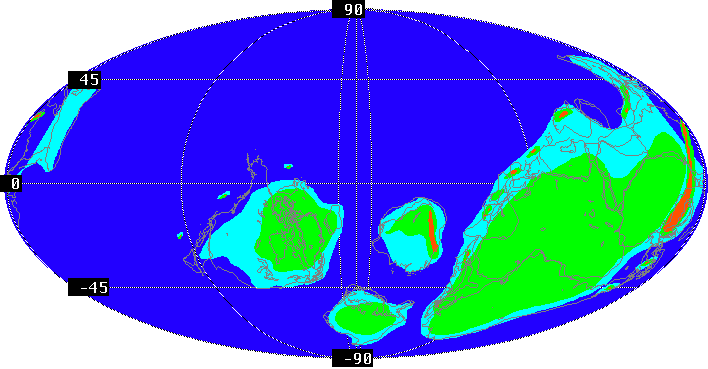
As you can see, the Cambrian world was concentrated in the southern hemisphere. The largest landmass (lower right) was Gondwana (a collection of today's southern continents). The second largest continent, Laurentia is just left of center in the map below, and includes most of North America (the southeastern US can be seen wedged between Africa and South America as part of Gondwana). Between Gondwana and Laurentia lie Siberia (just south of the equator) and Baltica (Scandinavia, eastern Europe, and European Russia). The rest of Europe and much of what is today Asia lay in fragments along the north coast of Gondwana.
These landmasses were scattered as a result of the fragmentation of the supercontinent Rodinia that had existed in the Late Proterozoic. Laurentia stradled the equator, while Baltica and Siberia were southeast of that continent. Tectonism affected regions of Gondwana is what are presently Australia, Antarctica, and Argentina the most. This is evident because of the presence of volcanic island arcs, which show that seafloor spreading and crustal subduction occurred. The continental plate movement and collisions during this period generated pressure and heat between continents. this resulted in the folding, faulting, and crumpling of rock which formed large mountain ranges.
The Cambrian world was bracketed between two ice ages, one during the late Late Proterozoic and the other during the Ordovician. During these ice ages, the decrease in global temperature led to mass extinctions. Cooler conditions eliminated many warm water species, and glaciation lowered global sea level. However, during the Cambrian there was no significant ice formation. None of the continents were located at the poles, and so land temperatures remained mild. In fact, global climate was probably warmer and more unifrom than it is today. With the beginning of the Cambrian at the retreat of Proterozoic ice, the sea level rose significantly. Lowland areas such as Baltica were flooded and much of the world was covered by epeiric seas. This event opened up new habitats where marine invertebrates, such as the trilobites, radiated and flourished.
Plants had not yet evolved, and the terrestrial world was therefore devoid of vegetation and inhospitable to life as we know it. Photosynthesis and primary production were the monopoly of bacteria and algal protists that populated the world's shallow seas.
Also during the Cambrian, oxygen first mixed into the world's oceans in significant quantity. Although there was plentiful atmospheric oxygen by the opening of the Cambrian, only in the Cambrian did the numbers of oxygen-depleting bacteria reduce in numbers sufficiently to permit the high levels we know today. This made dissolved oxygen available to the diversity of animals, and may have triggered the "Cambrian Explosion". This was when most of the major groups of animals, especially those with hard shells, first appear in the fossil record.
For additional maps of the Cambrian world, visit the Cambrian page at the Paleogeography Through Geologic Time site by Dr. Ron Blakey of Northern Arizona University.
Read about the Cambrian Mass Extinction at the Hooper Virtual Paleontology Museum.
Find out more about the Cambrian paleontology and geology of North America at the Paleontology Portal.