Western North America during the Sierra Nevada and Sevier orogenies. The Sierras have been fully accreted. A. The northern Sierras. B. Accretionary wedge that will form the northern Coast Range. C. The Mid-Continental Seaway.
Geologic history of the northern Sierra Nevada
A supplement to Paleobotany field trip to the Sierra Nevada
Day 1 |
Day 2 |
Day 3
Pre-Laramide history
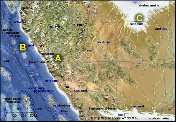
The Sierra Nevada, along with most of North America west of the Cordillera, is composed of tectonically accreted terranes of Paleozoic and Mesozoic age. Many of these terranes are exotic, in that they originated far from North America, and have complex histories of amalgamation and rotation. They are largely fragments of oceanic island arc complexes, but also include carbonate platforms, deep marine clastics, and even small cratonal fragments. These have been dispersed northward since the time of their accretion to North America by right lateral shear. Hence, some terrane rocks of western Canada and Alaska probably belonged to larger tectonic blocks that also included rocks that now belong to the Northern Sierras. The large New Melones Fault Zone passes through our field area roughly ten miles from the Rock Creek Power Dam and lies only about three miles southwest of Quincy. This is one of the major right lateral strike slip faults responsible for terrane dispersal.
|
Western North America during the Sierra Nevada and Sevier orogenies. The Sierras have been fully accreted. A. The northern Sierras. B. Accretionary wedge that will form the northern Coast Range. C. The Mid-Continental Seaway. |
The Laramide Orogeny and uplift of the Sierras
Cretaceous epicontinenal seas were terminated by extreme uplift and compression of the Far West by the monumental Laramide Orogeny of late Cretaceous to middle Eocene age. The Laramide Orogeny is thought to be a response to the subduction of warm and buoyant ocean floor produced during the Cretaceous spreading rate increase. This caused a dramatic decrease in subduction angle, moving the trench far offshore, telescoping and uplifting the west, and producing a wide volcanic arc which produced andesitic volcanism in Colorado, Wyoming, the interior Northwest, and northeastern Nevada. The "flat slab" episode profoundly shaped western North America, and mountain ranges extending from the coast to the Cordillera were produced during this event. In the Cordillera, flat slab compression caused dramatic overthrusting, which reflects as much as 100% regional shortening in the Laramide Rockies.
A major consequence is that lithosphere throughout the Far West is "rootless" because deep subcrustal rocks are thought to have been scraped off by the shallow flat slab. This further weakened accreted lithosphere that was already poorly consolidated; and since this time, lithosphere of the Far West has been prone to rifting, particularly behind the Sierras and Cascades.
 Middle Eocene Far West. A. The Laramide Rockies. B. The Northern Sierras. C. Borderland accretionary complex, now forming the northern Coast Range. Note the large drainages on the Sierra front. Arrow points to the Ancestral Yuba River System. |
Eocene paleofloras
Fossil preservational settings were abundant on the Laramide surface. Rapid deposition of volcanics and volcaniclastics within small lakes and broad floodplains captured abundant plant material. Outstanding Cretaceous to Eocene plant assemblages are found throughout the Green River Basin, Idaho (the Challis Volcanics), central Oregon (the Clarno Formation), and elsewhere. "Flat slab" era floras in California are not preserved in immature volcaniclastics, but typically in braidplains and transgressional deltaic sequences. These include Bridgerian and Uintan floras from the San Diego region, and highly fossiliferous deposits of the classic Chalk Bluffs flora, which are of concern to us. The assemblages described by MacGinitie (1941) are preserved within braidplains of channels deeply incised into the Laramide surface. In the northern Sierras, this surface is weathered to great depth by lateritic paleosols which reflect a humid, near tropical Paleocene-early middle Eocene environment. Into the laterites and underlying high grade rocks, deep channels were incised at some point prior to ~ 49-50 Ma. These channels, referred to as the "ancestral Yuba River system" were backfilled as sea level began to rise near ~48-49 Ma. Rising sea level produced the massive Ione Delta system west of Marysville and Sacramento, along with other transgressive deltas (the Ballenas Delta of San Diego, the Coaledo Delta of Oregon, and the Puget Delta of Washington).
Ancestral Yuba channels extended well into northwestern Nevada (Garside, 2005). It is within these channels that lag gravels containing California Gold Rush placer deposits are recovered. These were eroded from "mother lode" gold-bearing high grade rocks in the Tahoe region (Garside, 2005). The gravel-filled Yuba channels record a relatively high-gradient braided river system that existed 48-49 Ma. In addition to cobble clasts, channel lag includes abundant wood, including upright stumps. Following a brief retreat, sea level rose a second time ~ 45-46 Ma. During this transgression, gravel-filled channels were backfilled with sand, while channel margins and overbank facies received finer sediment. It is within these overbank and floodplain deposits that leaf, fruit and seed floras of the classic Chalk Bluff flora are preserved. A single radiometric date indicates that these floras are approximately 45.5 Ma. The paleogeography and local geological history of this period and region is discussed in more detail in the overview of the Buckeye Diggings locality of the Chalk Bluff flora later in the field guide.
The end of the Flat Slab period and the post-Eocene Yuba River
Ancestral Yuba channels remained active through the later middle Miocene. Additionally, auriferous gravels were continually reworked into younger channels, and paleofloras ranging from Eocene to Miocene age are found within them. Most notably, these include the latest Eocene La Porte flora, which is found within an ash-filled channel incising fossiliferous middle Eocene floodplain mudstone.
Immature volcanic ash filling the channel at La Porte reflects a renewal of highly silicic ignimbrite volcanism beginning in eastern Washington State near the early-middle Eocene boundary and sweeping through central Nevada by middle Miocene time. Called the "ignimbrite storm" this episode reflects catastrophic melting of continental rock thought to have been produced by the north to south tearoff of the flat slab and the subsequent juxtaposition of hot mantle asthenosphere under thin continental lithosphere. Oligocene and early Miocene rocks of Nevada consist of sheet after sheet of ignimbrite storm deposits, which fill the Yuba channels. Few fossils are preserved within them.
Breakoff of the flat slab was followed by renewed high angle subduction and construction of the Cascades volcanic arc. The arc initially formed ~ 40 Ma in Oregon/Washington and built southward over time as the Flat Slab tore. The Cascades arc extended through the northern Sierras by middle Miocene time, perforating Mesozoic rocks of the earlier subduction/accretion complex. Andesitic rocks of the "ancestral" or Western Cascades are abundantly fossiliferous, and include the most complete sequence of Eocene/Oligocene transitional paleofloras in North America. A number of paleofloras of middle Miocene age are preserved in what are interpreted to be debris-dam lake deposits of the southern part of the Western Cascades, which occupied the northern Sierra Nevada region. These include the Gold Lake, Webber Lake, and Mohawk floras found within the Mehrten Formation and its equivalents.
 Mid-late Miocene paleogeography. A. Northern Sierras. B. Subduction arc volcanoes extend to the Mendocino Triple Junction near the latitude of Monterey at this time. C. Basin-Range extension has dropped the Laramide surface east of the Sierras, and moved the Sierras northwest (arrow). Northern Coast Ranges are fully attached, and have been uplifted, producing the Central Valley. |
The transform fault boundary produced pervasive right lateral transtension throughout the region. This dragged more solid crust of the Sierran and western Mexican batholiths northward through the weakened accretionary lithosphere that surrounds them like almonds in a candy bar. As these solid blocks collided, they were dragged westward around each other, while simultaneously rotating and pulling west. The result of this motion was the formation of the California Transverse Ranges and extension of the Great Basin. The Northern Sierras and Klamath/Siskiyou ranges were pulled west, opening the Great Basin. In west central Nevada extension began ~ 16-17 Ma, first forming transtensional sag basins along the "Walker Lane," and later, beginning ~ 9 Ma, producing the fault-bounded horsts observed today. Motion on these earlier faults appears not to have been as extensive as more recent faulting; and the modern basins of the Great Basin began to form in earnest only ~ 5-6 Ma ago.
Abundant paleofloras are preserved within middle Miocene transtensional basins of the Walker Lane. Broad lakes formed within these moderate elevation basins, capturing plant organs, insects, and other fossil material. Abundant diatoms inhabited the lakes, and fossils are largely preserved in diatomite. Fossils preserve a record of deciduous broadleaved and conifer vegetation growing under a mesic temperate climate.
Closely-spaced fallout ash deposits provide 40Ar/39 Ar dates with small errors. Additionally, ash deposits have been widely correlated geochemically, permitting highly resolved inter- and intra-basin correlations. This detailed chronology permits the reconstruction of vegetational and floristic changes over short time periods. Profound summer drought, beginning 15 to 14.5 Ma formed the Mediterranean climate of the modern west, and extirpated mesic and humid plants. The relatives of these plants are now found in southeast Asia, and this event initiated vegetational and floristic trends responsible for the current plants and community structure of the California province. Seasonal drying gradually spread northward, while winter cold built from the north, trapping cold and drought intolerant vegetation in a climatic vise that resulted in the short, opportunistic growing season of today.
Down slope in the northern Sierras, deciduous broadleaved and conifer vegetation was replaced by evergreen hardwood forest. The middle-late Miocene Mehrten Formation consists of ring plane deposits around edifices of the Miocene Western Cascades in the Northern Sierras. Temporary debris-dam lake and floodplain facies preserve the Webber Lake, Gold Lake, Mohawk, Table Mountain, Remington Hill, and other paleofloras discussed in greater detail later in the field guide. During this time the coast built outward from west of Sacramento to the east bay, forming the fossil-rich later Miocene/Pliocene Neroly formation.
Return to the field trip:
Day 1 |
Day 2 |
Day 3
Maps adapted from originals on the Paleogeography of the Southwestern US website by Ronald C. Blakey, Northern Arizona University.