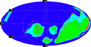
530 Million Years Ago
A few million years before the Tommotian, in the Vendian, the continents had been joined in a single supercontinent called Rodinia (from the Russian word for "homeland", rodina.) As the Cambrian began, Rodinia began to fragment into smaller continents which did not always correspond to the ones we see today. Much later, in the Permian, the continents came back together to form a new supercontinent, called Pangaea.
This reconstruction shows the rifting of Rodinia. Green represents land above water at this time, red indicates mountains, light blue indicates shallow continental shelf seas, and dark blue denotes the deep ocean basins. (For clarity, the outlines of present-day continents have been superimposed on this map.)

World climates were mild; there was no glaciation. Most of North America lay in warm southern tropical and temperate latitudes, which supported the growth of extensive shallow-water archaeocyathid reefs all through the Lower Cambrian. Siberia, which also supported abundant reefs, was a separate continent due east of North America. Baltica -- what is now Scandinavia, eastern Europe, and European Russia -- lay to the south. Most of the rest of the continents were joined in a supercontinent known as proto-Gondwana, depicted on the right side of the map; South America, Africa, Antarctica, India, and Australia are all visible. What is now China and east Asia was fragmented at the time, with the fragments visible north and west of Australia. Western Europe was also in pieces, with most of the pieces lying northwest of what is now the north African coastline. The present-day southeastern United States are visible wedged between South America and Africa; they did not become part of North America for another 300 million years.


